
Headwaters Employment Lands
Northwest Business Park - Headwaters
The Headwaters employment lands form an extension of the Northwest Business Park. This page provides context and resources to help landowners and developers of these lands collaborate with each other, community partners, utilities, and the City. Working together, all parties can help improve efficiencies, optimize land use, and contribute to land values while advancing industrial investment in Brantford.
Our Economic Development team remains available to help connect with the right resources to help advance development of these lands.
Background
The expansion of our municipal boundaries in 2017 is a key factor contributing to our long-term growth. As these new lands are developed for residential, commercial, and industrial use, the population is projected to reach 165,000 with 80,000 employees by 2051.
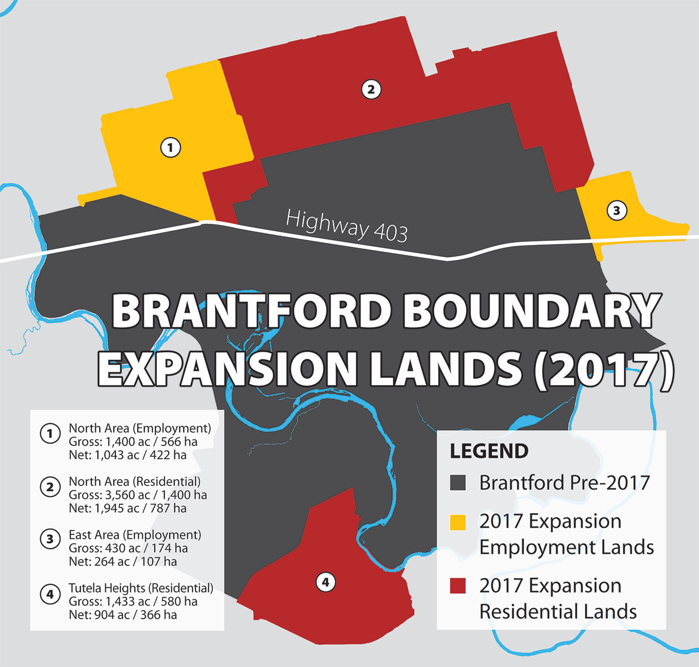
Part of this expansion includes approximately 1,400 acres of employment lands (see area #1 in the expansion lands map below) adjacent to the Northwest Business Park. This area contributes to the headwaters of what becomes Fairchild Creek, a tributary of the Grand River.
|
Map: 2017 boundary expansion lands |
 |
Developing the lands
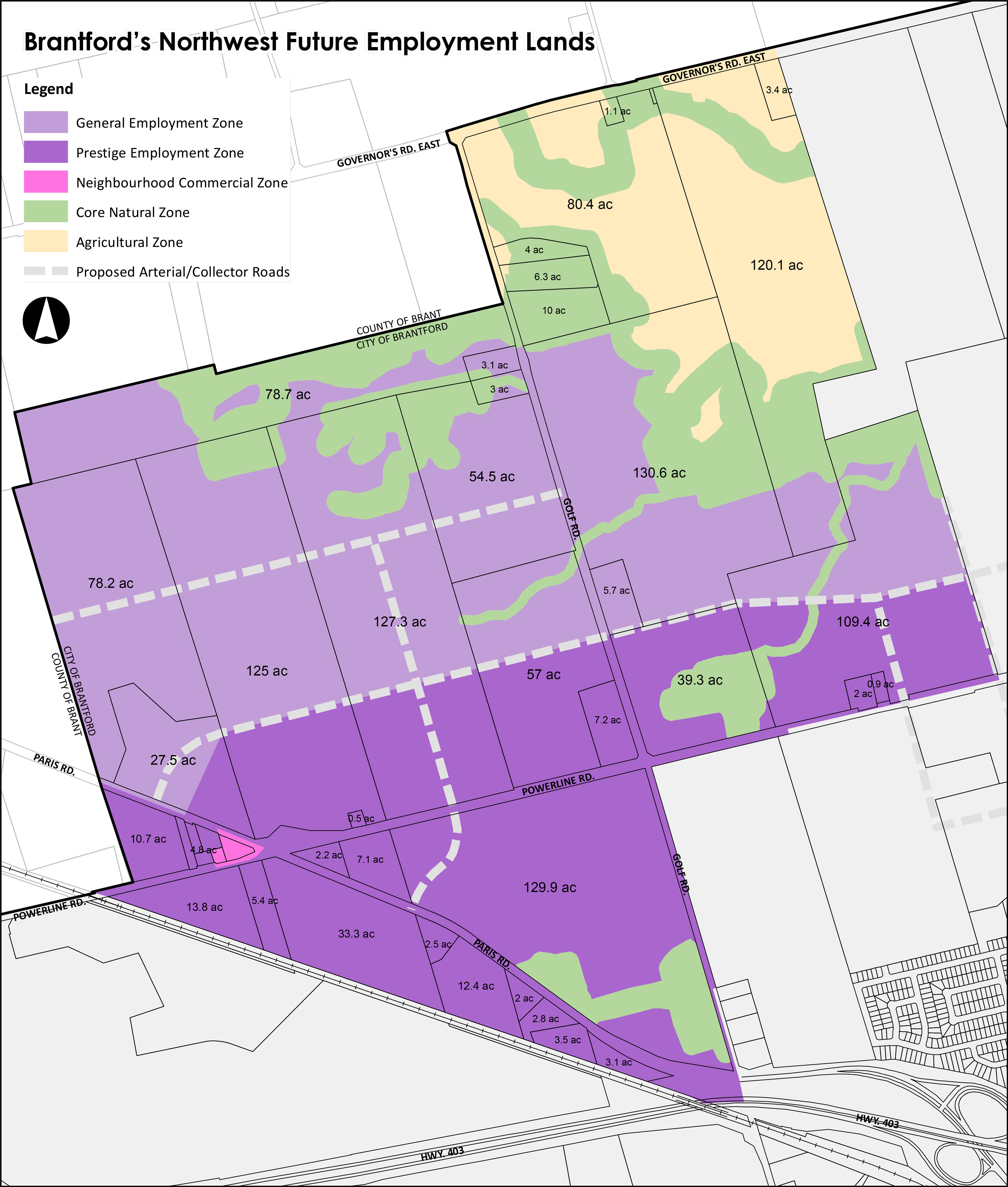
Council approved the City’s new Zoning By-law. These employment lands are zoned as either prestige employment (PE) or general employment (GE) with elements of core natural (N) throughout.
Residential lands to the east are presently undergoing a mandatory block planning process whereby landowners and community partners, including the City, collaborate to determine the best approach for ultimate development and usage. There is no obligatory block planning process for the PE and GE lands noted. However, a collaborative approach to the development of your lands and those of your neighbours may help optimize land value and improve usage for things such as supporting roadways, stormwater management, and service infrastructure. As these lands also represent great potential for our local economy, our Economic Development team can help guide the conversation to the mutual benefit of landowners and the community.
The map below helps provide some context for the discussion. It identifies property parcels and sizes, future zoning, existing infrastructure, and conceptual and likely-to-change service roads.
|
Map: Headwaters employment land area |
 |
Planning contacts and resources
The following resources and contacts will help landowners explore next steps in development with an eye on key infrastructure and servicing.
Development partners
- Enbridge Gas: Providing natural gas energy solutions to businesses, Enbridge will be an important partner in infrastructure planning as these lands are developed. The company delivers transparent pricing and reliable service to meet peak demands of businesses.
- Grand River Conservation Authority: The GRCA oversees the watershed of the Grand River. Their team of planners and engineers help shape conversations around natural waterways, stormwater, and general conservation.
- Grandbridge Energy: As the local power distributor, Grandbridge helps industrial businesses and developers facilitate new service connections, analyze power capacities, and explore opportunities for efficiencies and initiatives.
- NetOptics: As a leading local business-focused telecommunications company, NetOptics delivers custom data and internet connectivity solutions to fit business needs and support the bottom line.
City of Brantford
Land usage
- New zoning: Approved by Council September 24, 2024, the new City of Brantford Zoning By-law and associated Official Plan Amendment are now available.
- Official plan: An overview of the policies about how land within the municipality may develop and be used in the future.
Development process
- Planning process: Learn about the planning process and steps involved.
- Planning fees: View fees associated with the City’s planning process.
- Development charges: Development charges are adjusted annually and assist in financial capital projects required to meet the increased need for services resulting from growth and development. Development charges are calculated at building permit stage.
Environmental assessments
An Environmental Assessment is a process set out by the Provincial Government under the Environmental Assessment Act which requires that governments and public bodies consider potential environmental effects before construction of an infrastructure project begins.
Learn more about Environmental Assessments undertaken by the City.